| Sumdorong Chu | |
|---|---|
| Native name | གསུམ་རྡོ་རོང་ཆུ (Standard Tibetan) |
| Location | |
| Country | China; India |
| Region | Shannan, Tibet; Arunachal Pradesh |
| District | Tsona County; Tawang district |
| City | Lė Township; Zemithang Circle |
| Physical characteristics | |
| Source | Eastern Himalayas |
| • location | Lė Township |
| • coordinates | 27°47′44″N 91°49′18″E / 27.7956°N 91.8216°E |
| • elevation | 4,600 m (15,100 ft) |
| Mouth | Nyamjang Chu valley |
• coordinates | 27°48′00″N 91°44′42″E / 27.80°N 91.745°E |
• elevation | 2,350 m (7,710 ft) |
| Basin features | |
| Progression | Nyamjang Chu, Tawang Chu, Manas River |
| River system | Brahmaputra |
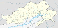
Sumdorong Chu (Tibetan: གསུམ་རྡོ་རོང་ཆུ, Wylie: gsum rdo rong chu; Chinese: 桑多洛河; pinyin: Sāng duō luò hé)[1] is a tributary of the Nyamjang Chu river that flows along the disputed Sino-Indian border between the Tsona County of Tibet and the Tawang district of Arunachal Pradesh. It originates in the Tokpo Shiri Glacier, about 7–10 kilometres east of Nyamjang Chu, and flows down to the river.[2] Its junction with Nyamjang Chu is about two kilometers to the north of that of Namka Chu, another contested river valley.
The Sumdorong Chu valley was the site of a standoff between India and China in 1986–1987 which, despite giving rise to the fears of another war, deescalated successfully. Subsequently, India and China formulated agreements for managing future border tensions.[3][4]
- ^ "India-China Border Dispute". GlobalSecurity.org. Retrieved 1 August 2017.
- ^ "Chinese troops in Kameng", The Hindustan Times, 17 July 1986, in China and South Asia (1987).
- ^ V. Natarajan (12 October 2006). "The Sumdorong Chu Incident". Bharat Rakshak. Retrieved 1 August 2017.
- ^ Pardesi, Managing the Sumdorong Chu Crisis (2020).

