| Summerville Formation | |
|---|---|
| Stratigraphic range: Oxfordian | |
 Summerville Formation at the type locality at Summerville Point, east side of the San Rafael Swell, Emery County, Utah | |
| Type | Geological formation |
| Unit of | San Rafael Group |
| Sub-units | Bluff Sandstone |
| Underlies | Morrison Formation |
| Overlies | Todilto & Curtis Formations |
| Thickness | 100 m (330 ft) |
| Lithology | |
| Primary | Mudstone, sandstone |
| Other | Gypsum |
| Location | |
| Coordinates | 39°12′58″N 110°32′38″W / 39.216°N 110.544°W |
| Approximate paleocoordinates | 31°54′N 54°42′W / 31.9°N 54.7°W |
| Region | Four Corners, (Southwestern United States) |
| Country | |
| Extent | Henry Mountains, Paradox Basin |
| Type section | |
| Named for | Summerville Point, Emery County, Utah |
| Named by | James Gilluly & J.B. Reeside Jr. |
| Year defined | 1928 |
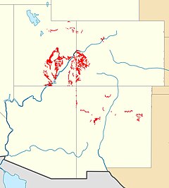
 Summerville Formation outcrops in Utah, Colorado and New Mexico | |
The Summerville Formation is a geological formation in New Mexico, Colorado, and Utah of the Southwestern United States. It dates back to the Oxfordian stage of the Late Jurassic.[1]
- ^ Wilcox 2007