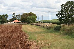
| Sunnyside Sugar Plantation | |
|---|---|
 Sunnyside Sugar Plantation, 2009 | |
| Location | 94 Windermere Road, Windermere, Bundaberg Region, Queensland, Australia |
| Coordinates | 24°51′15″S 152°24′55″E / 24.8543°S 152.4152°E |
| Design period | 1870s - 1890s (late 19th century) |
| Built | c. 1880s |
| Official name | Sunnyside Sugar Plantation (former) Remains, Dry-rubble Boundary Wall, Sunnyside Sugar Plantation |
| Type | state heritage (archaeological, built) |
| Designated | 13 May 1996 |
| Reference no. | 601700 |
| Significant period | 1880s (fabric) 1880s-1900s early (historical) |
| Builders | South Sea Islander labour |
Sunnyside Sugar Plantation is the heritage-listed remains of a former sugar plantation at 94 Windermere Road, Windermere, Bundaberg Region, Queensland, Australia. It was built in c. 1880s by South Sea Islander labour. It is also known as Dry-rubble Boundary Wall. It was added to the Queensland Heritage Register on 13 May 1996.[1]
- ^ "Sunnyside Sugar Plantation (former) Remains (entry 601700)". Queensland Heritage Register. Queensland Heritage Council. Retrieved 1 August 2014.

