| Superstition Mountain | |
|---|---|
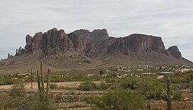
 Superstition Mountain as seen from the west over Apache Junction in 2002 | |
| Highest point | |
| Elevation | 5,059 ft (1,542 m) NAVD 88[1] |
| Prominence | 1,817 ft (554 m)[2] |
| Coordinates | 33°24′40″N 111°24′03″W / 33.411016967°N 111.400765347°W[1] |
| Naming | |
| Native name | |
| Geography | |
| Location | Pinal County, Arizona, US |
| Parent range | Superstition Mountains |
| Topo map | USGS Goldfield |
Superstition Mountain (Yavapai: Wi:kchsawa, O'odham: Gakoḍk) is a prominent mountain and regional landmark located in the Phoenix metropolitan area of Arizona, immediately east of Apache Junction and north of Gold Canyon. It anchors the west end of the Superstition Mountains (within the federally designated Superstition Wilderness Area) and is a popular outdoor recreation destination, home to numerous trails for hiking and horseback riding.[3] The legend of the Lost Dutchman's Gold Mine centers around the mountain.
- ^ a b "Superstition". NGS Data Sheet. National Geodetic Survey, National Oceanic and Atmospheric Administration, United States Department of Commerce. Retrieved June 8, 2011.
- ^ "Superstition Benchmark, Arizona". Peakbagger.com. Retrieved June 8, 2011.
- ^ Carlson, Jack; Stewart, Elizabeth (2017). Superstition Wilderness Trails West (1st ed.). Tempe, Arizona: Clear Creek Publishing. pp. 11, 29, 34–38, 157, 173–179, 188, 192–194, 214, 219, 241.
