This article possibly contains original research. (August 2019) |
Surathkal
ಸುರತ್ಕಲ್ | |
|---|---|
Neighbourhood/Suburb | |
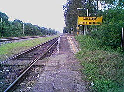
 Surathkal Railway Station | |
| Coordinates: 12°58′10″N 74°46′45″E / 12.96932°N 74.77915°E | |
| Country | |
| State | Karnataka |
| District | Dakshina Kannada |
| City | Mangalore |
| Region | Tulu Nadu |
| Elevation | 24 m (79 ft) |
| Population | |
| • Total | 61,259 |
| Languages | |
| • Official | Kannada |
| • Regional | Kannada, Tulu, Beary, Konkani |
| Time zone | UTC+5:30 (IST) |
| PIN | 575014 |
| Telephone code | 0824 |
Surathkal is one of the major localities[1] in the northern part of Mangalore city located on National Highway 66 (old NH-17) in the Dakshina Kannada district, Karnataka state, India on the shore of Arabian sea. It is a municipality merged with Mangalore City Corporation. It lies between Gurupura (Phalguni) and Pavanje (Nandini) rivers. It is the northern suburb and can be considered as the northernmost area of Mangalore City until Mukka. Surathkal has a railway station on Konkan railway route which connects cities of Mumbai to Mangaluru. Surathkal is 8 km north of New Mangalore seaport, 4 km west of Mangalore Refinery and Petrochemicals Limited and 16 km west of Mangalore International Airport This region has developed educationally, industrially and commercially can be regarded as one of the crucial localities in Mangaluru and coastal Karnataka. The only NIT of Karnataka is situated here which is adjacent to the national highway NH 66. Mukka a popular name in Indian surfing is also situated close to Surathkal. Surathkal beach is well known for its cleanliness and well maintained like other beaches in Mangalore.
- ^ "MCC will open zonal office at Surathkal tomorrow". The Times of India. 5 March 2017. Retrieved 6 October 2018.
