| Surbiton | |
|---|---|
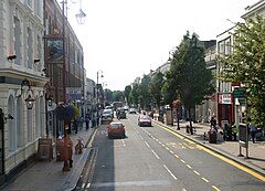
 Victoria Road, Surbiton's high street | |
Location within Greater London | |
| Area | 7.18 km2 (2.77 sq mi) |
| Population | 45,132 |
| • Density | 6,286/km2 (16,280/sq mi) |
| OS grid reference | TQ180673 |
| London borough | |
| Ceremonial county | Greater London |
| Region | |
| Country | England |
| Sovereign state | United Kingdom |
| Post town | SURBITON |
| Postcode district | KT5, KT6 |
| Dialling code | 020 |
| Police | Metropolitan |
| Fire | London |
| Ambulance | London |
| UK Parliament | |
| London Assembly | |
Surbiton is a suburban neighbourhood in South West London, within the Royal Borough of Kingston upon Thames (RBK). It is next to the River Thames, 11 miles (18 km) southwest of Charing Cross. Surbiton was in the historic county of Surrey and since 1965 it has been in Greater London. Surbiton comprises four of the RBK's wards: Alexandra, Berrylands, St. Mark's, and Surbiton Hill.[1]
Founded originally as Kingston-upon-Railway when the area was first developed in the 1840s,[2] Surbiton possesses a mixture of grand 19th-century townhouses, Art Deco courts, and more recent residential blocks blending in with semi-detached 20th-century housing estates. With a population of 45,132 in 2016, it accounts for approximately 25% of the total population of the Royal Borough of Kingston upon Thames.[3] Surbiton extends over an area of 7.18 km2 (2.77 sq mi).[4]
- ^ "Administrative Boundaries". www.maps.kingston.gov.uk. Royal Borough of Kingston upon Thames. Retrieved 7 February 2018.
- ^ Sampson, June (1991). All Change; Kingston, Surbiton & New Malden in the 19th century (2nd ed.). St. Luke's Church, Surbiton. pp. 2–4. ISBN 0950995800.
- ^ "Population". www.data.kingston.gov.uk. Royal Borough of Kingston upon Thames. Retrieved 7 February 2018.
- ^ "Standard Area Measurements (2016) for Administrative Areas in the United Kingdom". www.ons.maps.arcgis.com. Office for National Statistics. Retrieved 7 February 2018.
