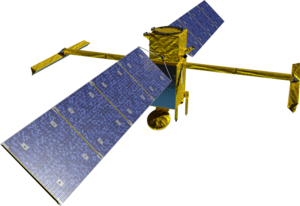
 Rendering of the SWOT satellite | |||||||||||||||||
| Names | SWOT WATER HM[1] | ||||||||||||||||
|---|---|---|---|---|---|---|---|---|---|---|---|---|---|---|---|---|---|
| Mission type | Hydrology / Oceanography | ||||||||||||||||
| Operator | NASA / CNES | ||||||||||||||||
| COSPAR ID | 2022-173A | ||||||||||||||||
| SATCAT no. | 54754 | ||||||||||||||||
| Mission duration | Planned: 3 years Elapsed: 1 year, 10 months and 28 days | ||||||||||||||||
| Spacecraft properties | |||||||||||||||||
| Manufacturer | Thales Alenia Space | ||||||||||||||||
| Launch mass | 2,200 kg (4,900 lb)[2] | ||||||||||||||||
| Dimensions | 14.9 × 5 × 5 m (49 × 16 × 16 ft)[2] | ||||||||||||||||
| Power | 8,000 watts[2] | ||||||||||||||||
| Start of mission | |||||||||||||||||
| Launch date | December 16, 2022, 11:46 UTC[3] | ||||||||||||||||
| Rocket | Falcon 9 Block 5 B1071.6 ♺ | ||||||||||||||||
| Launch site | Vandenberg, SLC-4E | ||||||||||||||||
| Contractor | SpaceX | ||||||||||||||||
| Orbital parameters | |||||||||||||||||
| Reference system | Geocentric | ||||||||||||||||
| Regime | Low Earth orbit | ||||||||||||||||
| Periapsis altitude | 857 km (533 mi) | ||||||||||||||||
| Apoapsis altitude | 857 km (533 mi) | ||||||||||||||||
| Inclination | 77.6° | ||||||||||||||||
| Period | 102.89 minutes | ||||||||||||||||
| Repeat interval | 1 sidereal day | ||||||||||||||||
| |||||||||||||||||
 Alternate SWOT Mission Patch by NASA | |||||||||||||||||
The Surface Water and Ocean Topography (SWOT) mission is a satellite altimeter jointly developed and operated by NASA and CNES, the French space agency, in partnership with the Canadian Space Agency (CSA) and UK Space Agency (UKSA).[4] The objectives of the mission are to make the first global survey of the Earth's surface water, to observe the fine details of the ocean surface topography, and to measure how terrestrial surface water bodies change over time.
While past satellite missions like the Jason series altimeters (TOPEX/Poseidon, Jason-1, Jason-2, Jason-3) have provided variation in river and lake water surface elevations at select locations, SWOT will provide the first truly global observations of changing water levels, stream slopes, and inundation extents in rivers, lakes, and floodplains. In the world's oceans, SWOT will observe ocean circulation at unprecedented scales of 15–25 km (9.3–15.5 mi), approximately an order of magnitude finer than current satellites. It does this using synthetic aperture radar interferometry.[5] Because it uses wide-swath altimetry technology, SWOT will almost completely observe the world's oceans and freshwater bodies with repeated high-resolution elevation measurements, allowing observations of variations.
- ^ "SWOT (Surface Water Ocean Topography)". eoPortal.org. Retrieved 26 August 2024.
- ^ a b c "SWOT: Quick Facts". jpl.nasa.gov. NASA / JPL. Retrieved 26 August 2024.
- ^ "Live coverage: SpaceX ready to launch U.S.-French environmental satellite". spaceflightnow.com. 16 December 2022. Retrieved 16 December 2022.
- ^ Bains, Navdeep (7 March 2016). "2016-17 Report on Plans and Priorities". Canadian Space Agency. Retrieved 18 December 2022.
- ^ Rodriguez, Ernesto; Fernandez, Daniel Esteban; Peral, Eva; Chen, Curtis W.; De Bleser, Jan-Willem; Williams, Brent (15 September 2017). "Wide-Swath Altimetry: A Review". In Stammer, Detlef; Cazenave, Anny (eds.). Satellite Altimetry Over Oceans and Land Surfaces. CRC Press. doi:10.1201/9781315151779-2. ISBN 978-1-315-15177-9.