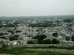
Suryapet
Suryapeta | |
|---|---|
 | |
| Nickname: Sun city | |
| Coordinates: 17°08′29″N 79°37′25″E / 17.1415°N 79.6236°E | |
| Country | |
| State | |
| District | Suryapet |
| Government | |
| • Type | Municipal |
| • Body | Suryapet Municipality |
| • MLA | Guntakandla Jagadish Reddy (BRS) |
| Area | |
• Total | 35 km2 (14 sq mi) |
| Elevation | 178 m (584 ft) |
| Population | |
• Total | 105,250[1] |
| • Rank | 10th (in Telangana) 306th (in India) |
| Languages | |
| • Official | Telugu, Urdu |
| Time zone | UTC+5:30 (IST) |
| PIN | 508 213 |
| Telephone code | 91-8684 |
| Vehicle registration | TG–29 |
| Sex ratio | 1000:923 ♂/♀ |
| HDI Category | medium |
| Literacy | 84.88% |
| Website | suryapetmunicipality |
Suryapet is a city in the Indian state of Telangana.[4][5] It is a municipality and the headquarters of its eponymous district. The Government of India announced Suryapet to be developed under the Atal Mission for Rejuvenation and Urban Transformation (AMRUT) scheme.[6] Suryapet has been awarded the "Cleanest city" in South India by the Ministry of Urban development in Swachh Survekshan 2017.[7][8] It is also known as "Gateway of Telangana".[9] It is located about 134 kilometres (83 mi) east of the state capital, Hyderabad and also it is located about 138 kilometres (86 mi) West of Vijayawada.
- ^ a b "Basic Information". Official website of Suryapet. Retrieved 21 February 2016.
- ^ "Cities, Towns and Outgrowth Wards". Citypopulation.de. Retrieved 19 September 2015.
- ^ "Census 2011". The Registrar General & Census Commissioner, India. Retrieved 3 May 2015.
- ^ "Cities having population 1 lakh and above, Census 2011" (PDF).
- ^ "Suryapet district" (PDF). New Districts Formation Portal. Archived from the original (PDF) on 11 October 2016. Retrieved 11 October 2016.
- ^ "AP identifies 31, Telangana 15 cities under AMRUT scheme". Eenadu English Portal. Archived from the original on 27 November 2015. Retrieved 29 November 2017.
- ^ Singh, S Bachan Jeet (1 May 2017). "Suryapet among top 10 cleanest cities in India". The New Indian Express. Retrieved 15 August 2019.
- ^ "Swachh Survekshan -2017 – ranks of 434 cities" (PDF). Archived from the original (PDF) on 12 July 2017. Retrieved 3 November 2017.
- ^ "Welcome to Suryapet Municipality". Archived from the original on 27 March 2018.

