Suryapet district | |
|---|---|
 | |
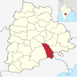
 Location in Telangana | |
| Country | India |
| State | Telangana |
| Established | 2016 |
| Headquarters | Suryapet |
| Mandalas | 23 |
| Government | |
| • District collector | Vinay Krishna Reddy[IAS] |
| • Parliament constituencies | Nalgonda and Bhuvanagiri |
| Area | |
• Total | 3,607 km2 (1,393 sq mi) |
| Population (2011) | |
• Total | 1,099,560 |
| • Density | 300/km2 (790/sq mi) |
| • Urban | 15.56% |
| Demographics | |
| • Literacy | 64.11% |
| • Sex ratio | 996 |
| Time zone | UTC+05:30 (IST) |
| Vehicle registration | TG–29[1] |
| Major highways | NH-65, NH167,NH-365B, NH-365BB and SH-42 |
| Website | suryapet |
Suryapet district is a district in the Indian state of Telangana.[2] The city of Suryapet is the district headquarters. The district has three revenue divisions Suryapet, Kodad and Huzurnagar. It is sub-divided into 23 mandals. The district shares boundaries with Nalgonda, Khammam, Yadadri, Jangaon and Mahabubabad districts and with Andhra Pradesh state.
- ^ "Telangana New Districts Names 2016 Pdf TS 31 Districts List". Timesalert.com. 11 October 2016. Retrieved 11 October 2016.
- ^ "Suryapet district" (PDF). New Districts Formation Portal. Archived from the original (PDF) on 11 October 2016. Retrieved 11 October 2016.
