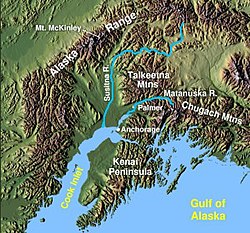
| Susitna River | |
|---|---|
 Susitna River in Southcentral Alaska | |
| Location | |
| Country | United States |
| Physical characteristics | |
| Source | |
| • coordinates | 63°26′10″N 147°11′55″W / 63.43611°N 147.19861°W[1] Susitna Glacier on Mount Hayes |
| • elevation | 2,500 ft (760 m) |
| Mouth | |
• coordinates | 61°16′14″N 150°34′33″W / 61.27056°N 150.57583°W[1] Cook Inlet of Pacific Ocean, at Matanuska-Susitna Borough, Alaska |
• elevation | 0 ft (0 m)[1] |
| Length | 313 mi (504 km)[2] |
| Basin size | 20,000 sq mi (52,000 km2)[2] |
| Discharge | |
| • average | 51,000 cu ft/s (1,400 m3/s) at mouth[2] |
The Susitna River (/suːˈsɪtnə/; Ahtena: Sasutna’; Tanaina: Susitnu) is a 313-mile (504 km) long river in the Southcentral Alaska. It is the 15th largest river in the United States, ranked by average discharge volume at its mouth.[2] The river stretches from the Susitna Glacier to Cook Inlet's Knik Arm.
