| Susquehanna River | |
|---|---|
 Susquehanna River in Bradford County, Pennsylvania | |
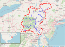
 Map of the Susquehanna River watershed | |
| Native name | Siskëwahane (Unami) |
| Location | |
| Country | United States |
| States | New York, Pennsylvania, Maryland[1] |
| Cities | (in order starting north and ending south) Binghamton, NY, Pittston, PA, Wilkes-Barre, PA, Williamsport, PA, Bloomsburg, PA, Northumberland, PA, Sunbury, PA, Harrisburg, PA (PA state capital), Port Deposit, MD, Havre de Grace, MD |
| Physical characteristics | |
| Source | Otsego Lake |
| • location | Cooperstown, Otsego County, New York, USA[2] |
| • coordinates | 42°42′02″N 74°55′10″W / 42.70056°N 74.91944°W |
| • elevation | 1,191 ft (363 m)[3] |
| Mouth | Chesapeake Bay |
• location | Havre de Grace, Cecil County / Harford County, Maryland, USA[2] |
• coordinates | 39°32′35″N 76°04′32″W / 39.54306°N 76.07556°W |
• elevation | 0 ft (0 m) |
| Length | 444 mi (715 km)[4] |
| Basin size | 27,500 sq mi (71,000 km2) |
| Discharge | |
| • location | Conowingo Dam, MD |
| • average | 40,670 cu ft/s (1,152 m3/s) |
| • minimum | 2,990 cu ft/s (85 m3/s) |
| • maximum | 1,130,000 cu ft/s (32,000 m3/s)June 24, 1972[5] |
| Discharge | |
| • location | Danville, PA |
| • average | 16,850 cu ft/s (477 m3/s)(Water years 1968-2019)[6] |
| Basin features | |
| Tributaries | |
| • left | Lackawanna River, Mahanoy Creek, Swatara Creek, Conestoga River, Little Mehoopany Creek |
| • right | Oaks Creek, Unadilla River, Chenango River, Chemung River, West Branch, Juniata River |
 | |
The Susquehanna River (/ˌsʌskwəˈhænə/ SUSS-kwə-HAN-ə; Lenape: Siskëwahane[7]) is a major river located in the Mid-Atlantic region of the United States, crossing three lower Northeast states (New York, Pennsylvania and Maryland). At 444 miles (715 km) long, it is the longest river on the East Coast of the United States.[8] By watershed area, it is the 16th-largest river in the United States,[9][10] and also the longest river in the early 21st-century continental United States without commercial boat traffic.
The Susquehanna River forms from two main branches: the North Branch, which rises in Cooperstown, New York, and is regarded by federal mapmakers as the main branch or headwaters,[11] and the West Branch, which rises in western Pennsylvania and joins the main branch near Northumberland in central Pennsylvania.
The river drains 27,500 square miles (71,000 km2), including nearly half of the land area of Pennsylvania. The drainage basin includes portions of the Allegheny Plateau region of the Appalachian Mountains, cutting through a succession of water gaps in a broad zigzag course to flow across the rural heartland of southeastern Pennsylvania and northeastern Maryland in the lateral near-parallel array of mountain ridges. The river empties into the northern end of the Chesapeake Bay at Perryville and Havre de Grace, Maryland, providing half of the Bay's freshwater inflow. The bay lies in the flooded valley, or ria, of the Susquehanna.
- ^ U.S. Geological Survey. National Hydrography Dataset high-resolution flowline data. The National Map Archived March 29, 2012, at the Wayback Machine, accessed August 8, 2011
- ^ a b "Susquehanna River". Geographic Names Information System. United States Geological Survey, United States Department of the Interior. Retrieved September 25, 2017.
- ^ "Otsego Lake". Geographic Names Information System. United States Geological Survey, United States Department of the Interior. Retrieved August 11, 2015.
- ^ "Susquehanna River Basin Map - Susquehanna River Basin Commission". docs.dcnr.pa.gov. 2019. Retrieved June 21, 2019.
data
- ^ "USGS 01578310 Susquehanna River at Conowingo, MD". United States Geological Survey. Archived from the original on March 3, 2016. Retrieved August 3, 2010.
- ^ "USGS 01540500 Susquehanna River at Danville, PA". United States Geological Survey. Retrieved November 6, 2020.
- ^ "Susquehanna River". Lenape Talking Dictionary. Archived from the original on November 13, 2013. Retrieved May 27, 2012.
- ^ "The Susquehanna River". Lewisburg, Pennsylvania: Susquehanna River Valley Visitors Bureau. Retrieved March 29, 2020.
- ^ Susquehanna River Trail Archived April 22, 2009, at the Wayback Machine Pennsylvania Fish and Boat Commission, accessed March 25, 2010.
- ^ Susquehanna River Archived April 17, 2015, at the Wayback Machine, Green Works Radio, accessed March 25, 2010.
- ^ "Susquehanna River". Geographic Names Information System. United States Geological Survey, United States Department of the Interior.