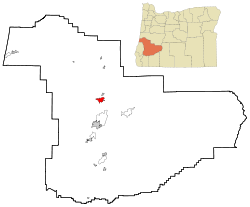
Sutherlin, Oregon | |
|---|---|
 The historic Sutherlin Bank Building (built 1910), located at 101 West Central Avenue in Sutherlin | |
| Nickname: City of Flags | |
 Location in Oregon | |
| Coordinates: 43°23′18″N 123°19′20″W / 43.38833°N 123.32222°W | |
| Country | United States |
| State | Oregon |
| County | Douglas |
| Incorporated | 1911 |
| Government | |
| • Mayor | Todd McKnight |
| Area | |
• Total | 6.19 sq mi (16.04 km2) |
| • Land | 6.11 sq mi (15.83 km2) |
| • Water | 0.08 sq mi (0.21 km2) |
| Elevation | 525 ft (160 m) |
| Population | |
• Total | 8,524 |
| • Density | 1,394.86/sq mi (538.53/km2) |
| Time zone | UTC-8 (Pacific) |
| • Summer (DST) | UTC-7 (Pacific) |
| ZIP code | 97479 |
| Area code | 541 |
| FIPS code | 41-71650[4] |
| GNIS feature ID | 2412018[2] |
| Website | www.ci.sutherlin.or.us |
Sutherlin is a city in Douglas County, Oregon, United States. As of the 2010 Census, the population was 7,810, making it the second most populous city in Douglas County. Located just off of Interstate 5, nearby features include Cooper Creek Reservoir, Ford's Pond (treated wastewater), the Umpqua River, a golf course, and numerous vineyards.

The City of Sutherlin Police Department also serves the City of Oakland via a paid contract.[5]
- ^ "ArcGIS REST Services Directory". United States Census Bureau. Retrieved October 12, 2022.
- ^ a b U.S. Geological Survey Geographic Names Information System: Sutherlin, Oregon
- ^ Cite error: The named reference
USCensusDecennial2020CenPopScriptOnlywas invoked but never defined (see the help page). - ^ Cite error: The named reference
wwwcensusgovwas invoked but never defined (see the help page). - ^ Bain, Dan (December 10, 2008). "Sutherlin agrees on policing deal". KPIC.com. Retrieved October 4, 2015.