| Sutton Bonington | |
|---|---|
| Village and civil parish | |
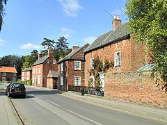
 Main Street | |
 Parish map | |
Location within Nottinghamshire | |
| Area | 3.48 sq mi (9.0 km2) |
| Population | 2,338 (2021 Census) |
| • Density | 672/sq mi (259/km2) |
| OS grid reference | SK 50469 25017 |
| • London | 115 mi (185 km) SSE |
| District | |
| Shire county | |
| Region | |
| Country | England |
| Sovereign state | United Kingdom |
| Settlements |
|
| Post town | LOUGHBOROUGH |
| Postcode district | LE12 |
| Dialling code | 01509 |
| Police | Nottinghamshire |
| Fire | Nottinghamshire |
| Ambulance | East Midlands |
| UK Parliament | |
| Website | www.suttonbonington |
Sutton Bonington (/ˈsʌtən ˈbɒnɪŋtən/) is a village and civil parish lying along the valley of the River Soar in the Borough of Rushcliffe, south-west Nottinghamshire, England. The University of Nottingham has the Sutton Bonington Campus, a 420 hectares (4.2 km2) site just to the north of the village.
The parish covers some 2,229 acres (9.02 km2)[1] and includes the hamlet of Zouch. The population at the 2011 census was 2,202, rising to 2,338 at the 2021 census.[2] The River Soar is the county boundary with Leicestershire and approximately 2 miles (3.2 km) to the north-west, in Leicestershire, is the large village of Kegworth. The nearest town is Loughborough, some 5 miles (8.0 km) by road to the south, and the nearest village is Normanton on Soar.
- ^ Sutton Bonington Local History Society Archived 11 May 2009 at the Wayback Machine Remember Sutton Bonington
- ^ "Civil Parish population 2021". City Population. Office for National Statistics. Retrieved 18 October 2023.
