| Swarcliffe | |
|---|---|
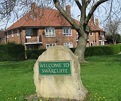
 Boundary Stone, from south | |
Location within West Yorkshire | |
| Population | 6,751 [1] |
| OS grid reference | SE36543620 |
| Metropolitan borough | |
| Metropolitan county | |
| Region | |
| Country | England |
| Sovereign state | United Kingdom |
| Post town | Leeds |
| Postcode district | LS14, LS15 |
| Dialling code | 0113 |
| Police | West Yorkshire |
| Fire | West Yorkshire |
| Ambulance | Yorkshire |
| UK Parliament | |
Swarcliffe, originally the Swarcliffe Estate, is a district of Leeds, West Yorkshire, England. It is 4.9 miles (8 km) east of Leeds city centre, and within the LS14 and LS15 Leeds postcode area. The district falls within the Cross Gates and Whinmoor ward of the Leeds Metropolitan Council.
In the 1950s, the Swarcliffe housing estate was developed, by the County Borough of Leeds, including semi detached council houses, three-storey blocks containing flats, and three brick-built, nine-storey blocks of flats. Two of these were demolished in the 1990s, and the third in 2007. A private finance initiative redevelopment of Swarcliffe began in 2006.
From 1955 to 1992, the MP for Leeds East constituency, including Swarcliffe, was Denis Healey.
In 2009, over 91% of the population in Swarcliffe were "hard-pressed".[1]

