This article needs additional citations for verification. (August 2024) |
| Symondsbury | |
|---|---|
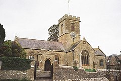
 Parish church of St John the Baptist | |
Location within Dorset | |
| Population | 1,059 [1] |
| OS grid reference | SY445936 |
| Unitary authority | |
| Shire county | |
| Region | |
| Country | England |
| Sovereign state | United Kingdom |
| Post town | Bridport |
| Postcode district | DT6 |
| Dialling code | 01308 |
| Police | Dorset |
| Fire | Dorset and Wiltshire |
| Ambulance | South Western |
| UK Parliament | |
Symondsbury (/ˈsɪməndzbəri/) is a village and civil parish in southwest Dorset, England, 1.5 miles (2.4 km) west of Bridport and 16 miles (26 km) west of Dorchester. The A35 road runs through the parish to the south of the village. The village has a pub (the Ilchester Arms), a pottery and a primary school. Symondsbury parish extends from Eype and West Cliff (West Bay) in the south, to the Marshwood Vale in the north. The village is in the Dorset National Landscape area. In the 2011 census the parish had a population of 1,059.
- ^ UK Census (2011). "Local Area Report – Symondsbury Parish (1170213604)". Nomis. Office for National Statistics. Retrieved 11 March 2018.
