| Synya Сыня | |
|---|---|
 View of the Synya at Ovgort | |
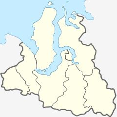
Mouth location in Yamalo-Nenets Autonomous Okrug, Russia | |
| Location | |
| Country | Russia |
| Physical characteristics | |
| Source | Polar Urals |
| • coordinates | 65°28′16″N 63°13′48″E / 65.47111°N 63.23000°E |
| • elevation | 53 m (174 ft) |
| Mouth | Ob |
• location | Malaya Ob |
• coordinates | 66°12′55″N 64°49′15″E / 66.21528°N 64.82083°E |
• elevation | 5 m (16 ft) |
| Length | 217 km (135 mi) (304 km (189 mi)) |
| Basin size | 13,500 km2 (5,200 sq mi) |
| Discharge | |
| • average | 96 m3/s (3,400 cu ft/s) (88 km (55 mi) from the mouth) |
| Basin features | |
| Progression | Ob→ Kara Sea |
The Synya (Russian: Сыня) is a river in Yamalo-Nenets Autonomous Okrug, Russia. The river is 217 kilometres (135 mi) long —304 km (189 mi) from the source of the Mokraya Synya at its head— and has a catchment area of 13,500 square kilometres (5,200 sq mi).[1]
The Synya flows across the Shuryshkarsky District. It is navigable for 90 kilometres (56 mi), between its mouth in the Ob and Ovgort village.[2]
- ^ "Река Сыня in the State Water Register of Russia". textual.ru (in Russian).
- ^ Cite error: The named reference
GSEwas invoked but never defined (see the help page).
