Tabatinga | |
|---|---|
 | |
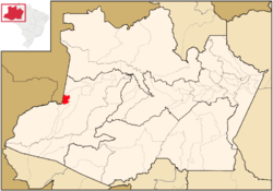
 Location of the municipality inside Amazonas | |
| Coordinates: 4°15′9″S 69°56′17″W / 4.25250°S 69.93806°W | |
| Country | |
| Region | North |
| State | |
| Founded | July 28, 1866 (Limits committee - Department of state of the Brazil) February 1, 1983 (Official foundation)[1] |
| Government | |
| • Mayor | Saul Nunes Bemerguy (Social Democratic Party) |
| Area | |
• Total | 3,225.064 km2 (1,245.204 sq mi) |
| Elevation | 60 m (200 ft) |
| Population (2020) | |
• Total | 67,182 |
| Time zone | UTC−5 (ACT) |
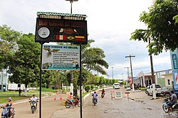
Tabatinga, originally Forte de São Francisco Xavier de Tabatinga, is a municipality in the Três Fronteiras area of Western Amazonas. It is in the Brazilian state of Amazonas. Its population was 67,182 (2020)[2] and its area is 3,225 km2.
Together with the neighbouring Colombian city of Leticia and the Peruvian city of Santa Rosa de Yavari, the urban area has more than 100,000 residents spread along the Amazon River. The first Portuguese settlement in the area was founded in the 18th century as a military outpost.[3] It became an autonomous municipality on February 1, 1983.[3] Formerly, it was part of the municipality of Benjamin Constant. The city is the seat of the Roman Catholic Diocese of Alto Solimões.
- ^ Panorama IBGE (Brazilian Institute of Geography and Statistics) cidades
.ibge .gov .br /brasil /am /tabatinga /panorama - ^ IBGE 2020
- ^ a b "Nossa Cidade" (in Portuguese). Portal Tabatinga. Archived from the original on 2008-02-12. Retrieved 2008-02-07.

