Tabio | |
|---|---|
Municipality and town | |
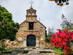
 Chapel of Santa Barbara | |
 Location of the municipality and town inside Cundinamarca Department of Colombia | |
| Coordinates: 4°54′57″N 74°5′54″W / 4.91583°N 74.09833°W | |
| Country | |
| Department | |
| Province | Central Savanna Province |
| Founded | 8 April 1603 |
| Founded by | Diego Gómez de Mena |
| Government | |
| • Mayor | Rubén Darío Acero García (2016-2019) |
| Area | |
| • Municipality and town | 74.5 km2 (28.8 sq mi) |
| • Urban | 0.43 km2 (0.17 sq mi) |
| Elevation | 2,569 m (8,428 ft) |
| Population (2015) | |
| • Municipality and town | 27,033 |
| • Density | 360/km2 (940/sq mi) |
| • Urban | 13,145 |
| Time zone | UTC-5 (Colombia Standard Time) |
| Website | Official website |
Tabio is a municipality and town of Colombia in the department of Cundinamarca. It's located at 45 km (28 mi) from Bogotá. The town was officially founded April 8, 1603, by Diego Gómez de Mena, on grounds that were the property of the native Muisca who inhabited the area. Tabio borders Zipaquirá in the north, Cajicá in the east, Subachoque in the west and Tenjo in the south.[1]
- ^ (in Spanish) Official website Tabio


