Taconite | |
|---|---|
| Nickname: Hub of the Nation | |
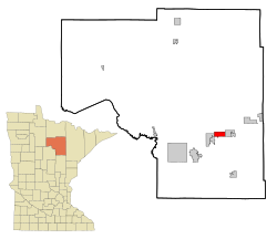
 Location of the city of Taconite within Itasca County, Minnesota | |
| Coordinates: 47°19′0″N 93°21′44″W / 47.31667°N 93.36222°W | |
| Country | United States |
| State | Minnesota |
| County | Itasca |
| Area | |
• Total | 29.62 sq mi (76.72 km2) |
| • Land | 27.97 sq mi (72.45 km2) |
| • Water | 1.65 sq mi (4.28 km2) |
| Elevation | 1,401 ft (427 m) |
| Population (2020) | |
• Total | 651 |
| • Density | 23.27/sq mi (8.99/km2) |
| Time zone | UTC-6 (Central (CST)) |
| • Summer (DST) | UTC-5 (CDT) |
| ZIP code | 55786 |
| Area code | 218 |
| FIPS code | 27-64048[3] |
| GNIS feature ID | 0658590[2] |
Taconite (/ˈtækənaɪt/ TAK-ə-nyte)[4] is a city in Itasca County, Minnesota, United States. The population was 651 at the 2020 census.[5]
U.S. Highway 169 serves as a main route in the community.
- ^ "2020 U.S. Gazetteer Files". United States Census Bureau. Retrieved July 24, 2022.
- ^ a b U.S. Geological Survey Geographic Names Information System: Taconite, Minnesota
- ^ "U.S. Census website". United States Census Bureau. Retrieved January 31, 2008.
- ^ "Minnesota Pronunciation Guide". Associated Press. Archived from the original on July 22, 2011. Retrieved July 4, 2011.
- ^ "Taconite, Minnesota". Census. Retrieved May 31, 2024.