| Taebaeksan | |
|---|---|
 Main peaks of Taebaeksan as viewed from Munsubong, another of its peaks | |
| Highest point | |
| Elevation | 1,566.7 m (5,140 ft) |
| Coordinates | 37°5′45″N 128°54′55″E / 37.09583°N 128.91528°E |
| Geography | |
| Location | South Korea |
| Parent range | Taebaek Mountains |
| Climbing | |
| Easiest route | Hike |
| Korean name | |
| Hangul | 태백산 |
| Hanja | |
| Revised Romanization | Taebaeksan |
| McCune–Reischauer | T'aebaeksan |
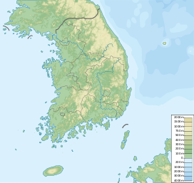
Taebaeksan, also known as Mount Taebaeksan or Mount Taebaek, is a South Korean mountain with several important peaks of the Taebaek mountain range (in Western-style geography), or the Taebaek Jeongmaek Range (in Korean-style geography). It is an important mountain in the Baekdu-daegan mountain range, the point where it turns west after running along Korea's east coast for a long distance. Its territory stretches from the city of Taebaek in Yeongwol-gun County, Gangwon-do Province to Bonghwa-gun County, Gyeongsangbuk-do Province, and it was designated South Korea's 22nd national park on 22 August 2016. It has an elevation of 1,566.7 m (5,140 ft).[1]
- ^ An Gyeong-ho (2003). 신 한국 100 명산 ('The New' 100 Korean Mountains). Seoul: 깊은솔 (Gipeunsol). p. 433. ISBN 89-89917-07-7.
