Taguatinga | |
|---|---|
| Região Administrativa de Taguatinga Administrative Region of Taguatinga | |
Clockwise from top: Skyline, Taguatinga Regional Hospital, Commercial road, King Pelé Tunnel, Taguaparque, Praça do Relógio | |
| Nickname: Taguá City | |
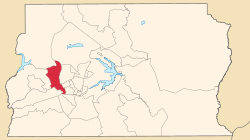
 Location of Taguatinga in the Federal District | |
| Coordinates: 15°50′00″S 48°03′23″W / 15.83333°S 48.05639°W | |
| Country | |
| Region | Central-West |
| State | |
| Founded | June 5, 1958 |
| Government | |
| • Regional administrator | Karolyne Guimarães dos Santos[1] |
| Area | |
| • Total | 121.34 km2 (46.85 sq mi) |
| Elevation | 1,000 m (3,000 ft) |
| Population (2010)[2] | |
| • Total | 221,909 |
| • Density | 1,828.8/km2 (4,737/sq mi) |
| Demonym | Taguatinguense |
| Time zone | UTC−3 (BRT) |
| Postal Code (CEP) | 72000-000 |
| Area code | +55 61 |
| Website | www.taguatinga.df.gov.br |
Taguatinga is an administrative region in the Federal District in Brazil. It is bordered by Brasília to the north, Vicente Pires, Águas Claras, and Arniqueira to the east, Riacho Fundo and Riacho Fundo II to the south, Samambaia to the southwest, Ceilândia to the west, and Brazlândia to the northwest. Taguatinga has a population of 222,598, being the fourth largest administrative region by population.
- ^ "Perfil da administradora" (in Portuguese). Administração Regional de Taguatinga, DF. Retrieved 2015-01-01.
- ^ "Pesquisa Distrital por Amostra de Domicílios - 2010/2011" (PDF) (in Portuguese). Codeplan. Retrieved 2012-08-20.[permanent dead link]


