Takaoka
高岡市 | |
|---|---|
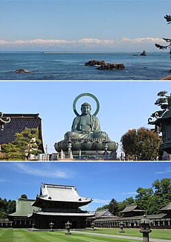
 From top: view of Tateyama Mountains from Amaharashi Coast, Takaoka Daibutsu, and Zuiryū-ji | |
 Location of Takaoka in Toyama Prefecture | |
| Coordinates: 36°45′14.6″N 137°1′32.4″E / 36.754056°N 137.025667°E | |
| Country | Japan |
| Region | Chūbu (Hokuriku) |
| Prefecture | Toyama |
| First official recorded | 701 AD |
| City settled | April 1, 1889 |
| Government | |
| • Mayor | Yuki Kakuda (from July 2021) |
| Area | |
• Total | 209.57 km2 (80.92 sq mi) |
| Population (March 10, 2018) | |
• Total | 173,086 |
| • Density | 830/km2 (2,100/sq mi) |
| Time zone | UTC+9 (Japan Standard Time) |
| Symbols | |
| • Tree | Persera thunbergii |
| • Flower | Katakuri (Katakago) |
| • Flowering tree | Sakura |
| Phone number | 0766-20-1111 |
| Address | 7-50 Hirokōji, Takaoka-shi, Toyama-ken 933-8601 |
| Climate | Cfa |
| Website | www |

Takaoka (高岡市, Takaoka-shi) is a city in the northwestern portion of Toyama Prefecture, Japan. Takaoka has the second largest population after Toyama City.
Takaoka is a center of western Toyama Prefecture. Western Toyama Prefecture is called "Gosei" (呉西) meaning the west of Kureha hill (呉羽丘陵, Kureha-kyuryo), meanwhile eastern Toyama Prefecture is called "Goto" (呉東) meaning the east of Kureha hill.
As of 2018[update], the city had an estimated population of 173,086 in 68,350 households and a population density of 819 persons per km2. Its total area was 209.57 square kilometres (80.92 sq mi).[1]


