Tala | |
|---|---|
 | |
| Coordinates: 34°50′10″N 32°25′51″E / 34.83611°N 32.43083°E | |
| Country | |
| District | Paphos District |
| Government | |
| • Community Council President | Areti Pieridou |
| Lowest elevation | 150 m (490 ft) |
| Population (2011)[2] | |
• Total | 2,695 |
| Climate | Csa |
| Website | www |

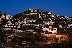
Tala (Greek: Τάλα) is a large suburban village 6 km north of Paphos, Cyprus. Many non-Cypriots (mostly British) have moved here permanently or have a summer home in Tala. Agios Neophytos Monastery is 1 km north. Is located 290 meters above sea level. [3][4] Tala receives an average annual rainfall of about 520 millimeters; grapevines (wine-making and table grape varieties), citrus fruits (orange trees, lemon trees), locust, olive, almond, and walnut trees, cereals, forage plants, vegetables, and a few banana trees are cultivated in the region. As far as stockbreeding is concerned, it is limited. [5][6]
- ^ "Community Council - Tala". Retrieved 2024-03-15.
- ^ "Population - Place of Residence, 2011". Statistical Service of Cyprus (CYSTAT). 17 April 2014. Archived from the original on 16 October 2014.
- ^ "GeoNames.org". www.geonames.org. Retrieved 2019-06-13.
- ^ "Forecast for Tála". yr.no. Retrieved 2019-06-13.
- ^ "Tala Village". Cyprus Island. 2017-03-15. Retrieved 2019-06-13.
- ^ "General – Tala". Retrieved 2019-06-13.
