Talawana Track | |
|---|---|
 | |
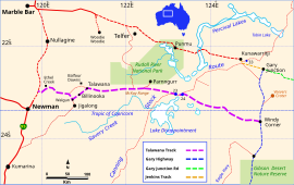
| Map of the Talawana Track in WA | |
 | |
| General information | |
| Type | Track |
| Length | 596 km (370 mi) |
| Opened | 1963 |
| Built by | Len Beadell, Gunbarrel Road Construction Party |
| Major junctions | |
| WNW end | Jigalong turn |
| ESE end | Windy Corner |
| Restrictions | |
| Permits | may be required |
| Fuel supply | none |
| ---- | |
The Talawana Track is a remote unsealed track that runs between Windy Corner on the Gary Highway and the Marble Bar Road in Western Australia, a distance of 596 kilometres.[1] The majority of it was built by Len Beadell and the Gunbarrel Road Construction Party in 1963 as part of a series of connecting roads for the Woomera rocket range in South Australia. It was the final road they built.
- ^ Hema, Maps (2005). Australia’s Great Desert Tracks NW Sheet (Map). Eight Mile Plains Queensland: Hema Maps. ISBN 978-1-86500-159-3.