This article is written like a travel guide. (June 2020) |
Taling Chan
ตลิ่งชัน | |
|---|---|
 New Southern Bus Terminal, a bus terminal in Taling Chan | |
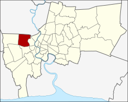
 Khet location in Bangkok | |
| Coordinates: 13°46′37″N 100°27′24″E / 13.77694°N 100.45667°E | |
| Country | Thailand |
| Province | Bangkok |
| Seat | Khlong Chak Phra |
| Khwaeng | 6 |
| Area | |
• Total | 29.479 km2 (11.382 sq mi) |
| Population (2017) | |
• Total | 105,299[1] |
| • Density | 3,572.00/km2 (9,251.4/sq mi) |
| Time zone | UTC+7 (ICT) |
| Postal code | 10170 |
| Geocode | 1019 |
Taling Chan (Thai: ตลิ่งชัน, pronounced [tā.lìŋ tɕʰān]) is one of the 50 districts (khet) of Bangkok, Thailand. Its neighbours, clockwise from the north, are Bang Kruai district of Nonthaburi province and Bang Phlat, Bangkok Noi, Bangkok Yai, Phasi Charoen, Bang Khae, and Thawi Watthana Districts of Bangkok.
- ^ "Population and House Report for Year 2017". Department of Provincial Administration, Ministry of Internal Affairs. Retrieved 2018-04-01. (Search page)