Tam O'Shanter-Sullivan | |
|---|---|
Neighbourhood | |
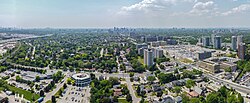
 Aerial view of Tam O'Shanter-Sullivan in 2023 | |
 Sullivan is west of Warden while Tam O'Shanter is east | |
| Coordinates: 43°47′17″N 79°18′05″W / 43.78806°N 79.30139°W | |
| Country | |
| Province | |
| City | Toronto |
| Established | 1850 Scarborough Township |
| Changed municipality | 1998 Toronto from City of Scarborough |
| Government | |
| • MP | Jean Yip (Scarborough—Agincourt) |
| • MPP | Aris Babikian (Scarborough—Agincourt) |
| • Councillor | Nick Mantas (Ward 22 Scarborough—Agincourt) |
Tam O'Shanter-Sullivan is a neighbourhood in the east end of the city of Toronto, Ontario, Canada, in the district of Scarborough. The neighbourhood is bordered by Huntingwood Drive to the North, Kennedy Road to the East, Highway 401 to the South and Victoria Park (and Pharmacy Ave) to the West. The neighbourhood, which includes the Tam O'Shanter (east of Warden) and Sullivan (west of Warden) communities, takes its name from Tam O’Shanter Golf Course and O'Sullivan's Corners.
The neighbourhood is sometimes included as part of the neighbourhood of Agincourt, which borders Tam O'Shanter to the east. Both regions are part of the electoral district of Scarborough—Agincourt, and the Agincourt Mall is located in Tam O'Shanter.