| Tambopata River | |
|---|---|
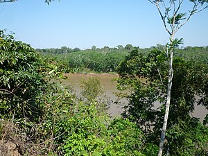
 Tambopata River in the Amazon rainforest in Peru | |
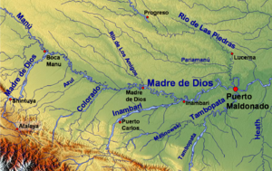
 Madre de Dios watershed with the Tambopata River in the southeast (upper parts of the river not included on the map) | |
| Location | |
| Country | Bolivia, Peru |
| Physical characteristics | |
| Source | Andes |
| • location | La Paz Department, Bolivia |
| Mouth | Madre de Dios River |
• coordinates | 12°35′48″S 69°10′10″W / 12.59667°S 69.16944°W |
| Length | 350 km (220 mi)[1] |
The Tambopata River is a river in southeastern Peru and northwestern Bolivia. Most of the Tambopata is in the Madre de Dios and Puno regions in Peru, but the upper parts of the river forms the border between Peru and Bolivia, and its origin is in La Paz department in Bolivia. The Tambopata is a tributary of the Madre de Dios River, into which it merges at the city of Puerto Maldonado. The river flows through the Tambopata National Reserve.
Seven types of flooded forest are recognized for this Reserve:[2]
- Permanently waterlogged swamp forests are former oxbow lakes still flooded but covered in forest.
- Seasonally waterlogged swamp forests are oxbow lakes in the process of filling in.
- Lower floodplain forest are the lowest floodplain locations with a recognizable forest.
- Middle floodplain forests are tall occasionally flooded forests.
- Upper floodplain forests are tall rarely flooded forests.
- Old floodplain forests have been subjected to flooding within the last two hundred years.
- Previous floodplain are now terra firme, but were historically ancient floodplains.
- ^ Ziesler, R.; Ardizzone, G.D. (1979). "Amazon River System". The Inland waters of Latin America. Food and Agriculture Organization of the United Nations. ISBN 92-5-000780-9. Archived from the original on 21 October 2013.
- ^ Phillips, O.; Gentry, A.H.; Reynel, C.; Wilkin, P.; Galvez-Durand b, C. (1994). "Quantitative Ethnobotany and Amazonian Conservation". Conservation Biology. 8 (1): 225–48. doi:10.1046/j.1523-1739.1994.08010225.x.