This article needs additional citations for verification. (June 2013) |
Tanauan | |
|---|---|
| Municipality of Tanauan | |
 View of a part of Tanauan's beach, looking towards the south. | |
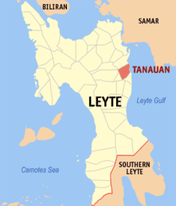
 Map of Leyte with Tanauan highlighted | |
Location within the Philippines | |
| Coordinates: 11°07′N 125°01′E / 11.12°N 125.02°E | |
| Country | Philippines |
| Region | Eastern Visayas |
| Province | Leyte |
| District | 1st district |
| Founded | 1710 |
| Barangays | 54 (see Barangays) |
| Government | |
| • Type | Sangguniang Bayan |
| • Mayor | Gina E. Merilo |
| • Vice Mayor | Archie Kapunan |
| • Representative | Ferdinand Martin G. Romualdez |
| • Councilors | List |
| • Electorate | 37,179 voters (2022) |
| Area | |
| • Total | 78.41 km2 (30.27 sq mi) |
| Elevation | 9.0 m (29.5 ft) |
| Highest elevation | 305 m (1,001 ft) |
| Lowest elevation | 0 m (0 ft) |
| Population (2020 census)[3] | |
| • Total | 57,455 |
| • Density | 730/km2 (1,900/sq mi) |
| • Households | 14,892 |
| Economy | |
| • Income class | 2nd municipal income class |
| • Poverty incidence | 24.70 |
| • Revenue | ₱ 181.7 million (2020) |
| • Assets | ₱ 598.3 million (2020), 202.6 million (2012) |
| • Expenditure | ₱ 170 million (2020) |
| • Liabilities | ₱ 115.7 million (2020) |
| Service provider | |
| • Electricity | Don Orestes Romualdez Electric Coperative (DORELCO) |
| Time zone | UTC+8 (PST) |
| ZIP code | 6502 |
| PSGC | |
| IDD : area code | +63 (0)53 |
| Native languages | Waray Tagalog |
| Website | www |
Tanauan (IPA: [tɐn'ʔaʊɐn]), officially the Municipality of Tanauan (Waray: Bungto han Tanauan; Tagalog: Bayan ng Tanauan), is a 2nd-class municipality in the province of Leyte, Philippines. According to the 2020 census, it has a population of 57,455 people.[3]
Tanauan is one of the oldest towns in Leyte, dating back to the year 1710. It is composed of 54 barangays. The town has also been known as the “Cradle of Intellectuals”, or the Bungto han Kamag-araman, since the Spanish colonial era.[5] Tanauan is approximately 18 kilometers south of Tacloban City, the capital of the Eastern Visayas Region. It is bounded on the north by the municipality of Palo, Tolosa on the south, Dagami and Tabon-tabon on its west side and on the east by San Pedro Bay.
The town was heavily damaged by Super Typhoon Haiyan (Yolanda) in November 2013. The town celebrates its fiesta annually on August 15.[6]
- ^ Municipality of Tanauan | (DILG)
- ^ "2015 Census of Population, Report No. 3 – Population, Land Area, and Population Density" (PDF). Philippine Statistics Authority. Quezon City, Philippines. August 2016. ISSN 0117-1453. Archived (PDF) from the original on May 25, 2021. Retrieved July 16, 2021.
- ^ a b Census of Population (2020). "Region VIII (Eastern Visayas)". Total Population by Province, City, Municipality and Barangay. Philippine Statistics Authority. Retrieved 8 July 2021.
- ^ "PSA Releases the 2021 City and Municipal Level Poverty Estimates". Philippine Statistics Authority. 2 April 2024. Retrieved 28 April 2024.
- ^ "Researchers Probe Possible Origin of Tinikling Folkdance in Leyte". Philippine Information Agency. August 28, 2006.
- ^ Cite error: The named reference
:2was invoked but never defined (see the help page).


