| Tanggula Mountains | |
|---|---|
| Tangla, Tanglha, Dangla Mountains | |
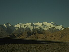
 Tanggula Mountains viewed from Qinghai. | |
| Highest point | |
| Peak | Geladaindong Peak |
| Geography | |
 | |
| Country | |
| Province/Region | Qinghai and Tibet Autonomous Region |
| Range coordinates | 33°30′00″N 91°04′12″E / 33.50000°N 91.07000°E |
The Tanggula (Chinese: 唐古拉山, p Tánggǔlāshān, or 唐古拉山脉, p Tánggǔlāshānmài), Tangla, Tanglha, or Dangla Mountains (Tibetan: གདང་ལ་།, w Gdang La, z Dang La) is a mountain range in the central part of the Qinghai-Tibet Plateau in Tibet.[1] Administratively, the range is in the Nagqu Prefecture of the Tibet Autonomous Region, with the central section extending into the Tanggula Town and the eastern section entering the Yushu Tibetan Autonomous Prefecture of Qinghai province.
Tanggula is the source of the Ulan Moron and Dangqu Rivers, the geographic headwaters of the Yangtze River. It functions as a dividing range between the basin of the Yangtze in the north and the endorheic basin of northeastern Tibet in the south.
- ^ "Tanggula Mountains". Encyclopædia Britannica. Retrieved 2007-07-03.