Tangipahoa Parish | |
|---|---|
 Columbia Theatre for the Performing Arts in Hammond | |
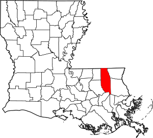
 Location within the U.S. state of Louisiana | |
 Louisiana's location within the U.S. | |
| Coordinates: 30°37′36″N 90°24′20″W / 30.62665°N 90.40568°W | |
| Country | |
| State | |
| Founded | March 6, 1869 |
| Named for | Acolapissa word meaning ear of corn or those who gather corn |
| Seat | Amite City |
| Largest city | Hammond |
| Area | |
| • Total | 823 sq mi (2,130 km2) |
| • Land | 791 sq mi (2,050 km2) |
| • Water | 32 sq mi (80 km2) 3.9% |
| Population | |
| • Total | 133,157 |
| • Density | 160/sq mi (62/km2) |
| Time zone | UTC−6 (Central) |
| • Summer (DST) | UTC−5 (CDT) |
| Congressional districts | 1st, 5th |
| Website | www |

Tangipahoa Parish ( /ˌtændʒɪpəˈhoʊə/) is a parish located on the southeastern border of the U.S. state of Louisiana. As of the 2020 census, the population was 133,157.[2] The parish seat is Amite City,[3] while the largest city is Hammond. Southeastern Louisiana University is located in Hammond. Lake Pontchartrain borders the southeastern side of the parish.
The name Tangipahoa comes from an Acolapissa word meaning "ear of corn" or "those who gather corn." The parish was organized in 1869 during the Reconstruction era.[4]
Tangipahoa Parish comprises the Hammond, LA Metropolitan Statistical Area, which is also included in the Baton Rouge–Hammond, LA Combined Statistical Area.[5] It is one of what are called the Florida Parishes, at one time part of West Florida.
- ^ "Tangipahoa Parish, Louisiana; United States". QuickFacts. United States Census Bureau. July 1, 2021. Retrieved February 2, 2022.
- ^ "Census - Geography Profile: Tangipahoa Parish, Louisiana". United States Census Bureau. Retrieved January 22, 2023.
- ^ "Find a County". National Association of Counties. Retrieved June 7, 2011.
- ^ "Tangipahoa Parish". Center for Cultural and Eco-Tourism. Retrieved September 5, 2014.
- ^ Van Leuven, Andrew J. (August 4, 2023). "Recent Changes to U.S. Metropolitan and Micropolitan Areas". Andrew J. Van Leuven, Ph.D. Retrieved January 11, 2024.