Tanhuato | |
|---|---|
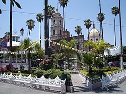
 The main square in Tanhuato de Guerrero in 2006 | |
 Location of Tanhuato in Michoacán | |
| Coordinates: 20°16′55″N 102°19′55″W / 20.28194°N 102.33194°W[1] | |
| Country | |
| State | |
| Established | 10 December 1831 |
| Seat | Tanhuato de Guerrero |
| Government | |
| • President | Héctor Daniel Aranda Pérez |
| Area | |
| • Total | 228.732 km2 (88.314 sq mi) |
| Elevation [1] (of seat) | 1,543 m (5,062 ft) |
| Population (2010 Census)[3] | |
| • Total | 15,176 |
| • Estimate (2015 Intercensal Survey)[4] | 15,352 |
| • Density | 66/km2 (170/sq mi) |
| • Seat | 9,546 |
| Time zone | UTC-6 (Central) |
| • Summer (DST) | UTC-5 (Central) |
| Postal codes | 59230–59244[5] |
| Area code | 356 |
| Website | Official website |
Tanhuato is a municipality in the Mexican state of Michoacán. It is located approximately 135 kilometres (84 mi) northwest of the state capital of Morelia.
- ^ a b "Sistema Nacional de Información Municipal" (in Spanish). SEGOB. 2010. Retrieved 9 January 2021.
- ^ "Tanhuato". Enciclopedia de los Municipios y Delegaciones de México (in Spanish). INAFED. Retrieved 9 January 2021.
- ^ a b "Tanhuato: Datos generales". Cédulas de información municipal (in Spanish). SEDESOL. 2013. Retrieved 9 January 2021.
- ^ Panorama sociodemográfico de Michoacán de Ocampo 2015 (PDF) (in Spanish). INEGI. 2016. p. 188. ISBN 978-607-739-850-9. Retrieved 9 January 2021.
- ^ "Consulta de Códigos Postales". Catálogo Nacional de Códigos Postales. Mexican Postal Service. 8 January 2021. Retrieved 9 January 2021.
