| Tank Stream | |
|---|---|
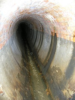
 Brick-lined section of the Tank Stream, pictured in November 2008 | |
Location in Sydney central business district | |
| Location | |
| Country | Australia |
| State | New South Wales |
| Local government area | City of Sydney |
| Physical characteristics | |
| Source | Hyde Park |
| • location | Sydney CBD |
| • coordinates | 33°52′13.2″S 151°12′27.9″E / 33.870333°S 151.207750°E |
| Mouth | Sydney Cove |
• location | Circular Quay |
• coordinates | 33°51′50.0472″S 151°12′31.1688″E / 33.863902000°S 151.208658000°E |
| Basin features | |
| River system | Port Jackson |
| Official name | Tank Stream; Tank Stream Fountain Circular Quay |
| Type | State heritage (built) |
| Designated | 2 April 1999 |
| Reference no. | 636 |
| Type | Spring |
| Category | Utilities - Water |
| Builders | Various |


The Tank Stream is a heritage-listed former fresh water tributary of Sydney Cove and now tunnel and watercourse located in the Sydney central business district, in the City of Sydney local government area of New South Wales, Australia. The Tank Stream was the fresh water supply for the fledgling colony of New South Wales in the late 18th century. Today it is little more than a storm water drain. It originated from a swamp to the west of present-day Hyde Park and at high tide entered Sydney Cove at what is now the intersection of Bridge and Pitt Streets in the Sydney central business district. The catchment was 65 hectares (161 acres), corresponding roughly the size of the Sydney central business district. It was added to the New South Wales State Heritage Register on 2 April 1999.[1]
- ^ "Tank Stream". New South Wales State Heritage Register. Department of Planning & Environment. H00636. Retrieved 13 October 2018.
 Text is licensed by State of New South Wales (Department of Planning and Environment) under CC BY 4.0 licence.
