| Tanner Trail | |
|---|---|
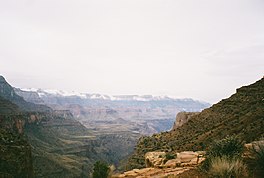
 A view of Tanner Canyon | |
| Length | 9 mi (14 km) |
| Location | Grand Canyon National Park, Arizona, United States |
| Trailheads | Lipan Point Colorado River Grand Canyon (South Rim) |
| Use | Hiking Backpacking |
| Elevation change | 4,750 ft (1,450 m) |
| Highest point | Lipan Point, 7,400 ft (2,300 m) |
| Lowest point | Colorado River, 2,650 ft (810 m) |
| Difficulty | Very strenuous |
| Season | Early Spring to Late Fall |
| Sights | Grand Canyon Colorado River |
| Hazards | Severe weather Overexertion Dehydration Flash flood |
The Tanner Trail is a hiking trail located on the South Rim of the Grand Canyon National Park, located in the U.S. state of Arizona. The trailhead is located at Lipan Point, a prominent lookout located to the east of the Grand Canyon Village, and the trail ends at the Colorado River at Tanner Rapids.[1]
- ^ National Geographic Maps Trails Illustrated:Grand Canyon National Park