This article needs additional citations for verification. (April 2022) |
Tannourine
تنورين | |
|---|---|
Town | |
 Tannourine | |
| Coordinates: 34°11′00″N 35°54′11″E / 34.18333°N 35.90306°E | |
| Country | Lebanon |
| District | Batroun |
| Area | |
• Total | 95 km2 (37 sq mi) |
| Population (2018) | |
• Total | 25,000 |
| Time zone | UTC+2 (Beirut) |
| • Summer (DST) | +3 |
| Area code | +961 (06) |
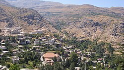
Tannourine (Arabic: تنورين, also Tannoureen, Tannorine) is a Lebanese town located in the Batroun District, part of the Governorate of North Lebanon, 80 km from the capital Beirut. Tannourine is formed by a cluster of mountain settlements located in the highs of the Batroun District, the largest of which is Tannourine El-Fawqa, followed by Chatine,Tannourine El-Tahta, and Wata Houb. Tannourine has a population of approximately 25,000.[citation needed]
Tannourine extends between the municipal borders of Douma and Yammoune, and between Aqoura to the south and Bsharri and Hadath El Jebbeh to the north. The town is close to the Kadisha Valley and Cedars of God UNESCO World Heritage Site, the Afqa grotto, the Baatara sinkhole, and the Nahr Ibrahim valley.
Tannourine lies in a collection of valleys and ravines accessible either from Douma, Kfour Al Arbe, a backroad from Bsharri or from a newly constructed highway direct from Batroun, or from Laqlouq.
Among the personalities born in or connected to Tannourine through family roots, one can remember;
- Julio César Turbay Ayala, 25th President of Colombia from 1978 to 1982.
- Shakira, singer.
- Assia Dagher, Lebanese-Egyptian actress and film producer.
- Abeer Nehme, singer and a musicologist.
- Pierre Dagher, Lebanese actor and voice actor.
- Charbel Dagher, Lebanese academic.
