Taopi, Minnesota | |
|---|---|
 MN-56 runs through Taopi. | |
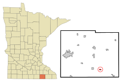
 Location in Mower County and the state of Minnesota | |
| Coordinates: 43°33′27″N 92°38′25″W / 43.55750°N 92.64028°W[1] | |
| Country | United States |
| State | Minnesota |
| County | Mower |
| Area | |
| • Total | 0.39 sq mi (1.01 km2) |
| • Land | 0.39 sq mi (1.01 km2) |
| • Water | 0.00 sq mi (0.00 km2) |
| Elevation | 1,342 ft (409 m) |
| Population | |
| • Total | 61 |
| • Density | 156.01/sq mi (60.24/km2) |
| Time zone | UTC-6 (Central (CST)) |
| • Summer (DST) | UTC-5 (CDT) |
| ZIP code | 55977 |
| Area code | 507 |
| FIPS code | 27-64210[4] |
| GNIS feature ID | 2396030[1] |
Taopi (/teɪˈoʊpi/ tay-OH-pee)[5] is a city in Mower County, Minnesota, United States. The population was 61 at the 2020 census.[2] It is located near the source of the Wapsipinicon River.
- ^ a b c U.S. Geological Survey Geographic Names Information System: Taopi, Minnesota
- ^ a b "2023 U.S. Gazetteer Files: Minnesota". United States Census Bureau. Retrieved February 12, 2024.
- ^ "P1. Race – Taopi city, Minnesota: 2020 DEC Redistricting Data (PL 94-171)". U.S. Census Bureau. Retrieved February 12, 2024.
- ^ "U.S. Census website". United States Census Bureau. Retrieved January 31, 2008.
- ^ "Minnesota Pronunciation Guide". Associated Press. Archived from the original on July 22, 2011. Retrieved July 4, 2011.