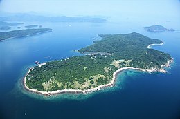
塔門 | |
|---|---|
 | |
 Map showing the location of Grass Island within Hong Kong | |
| Geography | |
| Location | Tai Po District |
| Coordinates | 22°28′35″N 114°21′45″E / 22.47639°N 114.36250°E |
| Area | 1.69 km2 (0.65 sq mi) |
| Administration | |
| Demographics | |
| Population | 100 (approx) |
| Tap Mun | |||||||||
|---|---|---|---|---|---|---|---|---|---|
| Traditional Chinese | 塔門 | ||||||||
| |||||||||


Grass Island or Tap Mun is an island in Hong Kong, located in the northeastern part of the territory. Its area is 1.69 km2 (0.65 sq mi).[1] Administratively, it is part of the Tai Po District. There are about 100 people living on the island, and feral cattle are known on the island.[2]
- ^ Survey and Mapping Office, Lands Department: Hong Kong geographic data sheet
- ^ 陳漢榮. 陳盛臣. 2003. 短線遊:跟住牛屎遊塔門. Retrieved on May 08, 2017