Tapanahoni | |
|---|---|
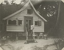
 Diitabiki (1907) | |
 Map showing the resorts of Sipaliwini District. Tapanahony | |
| Country | |
| District | Sipaliwini District |
| Area | |
• Total | 38,965 km2 (15,044 sq mi) |
| Population (2012)[2] | |
• Total | 13,808 |
| • Density | 0.35/km2 (0.92/sq mi) |
| Time zone | UTC-3 (AST) |
Tapanahoni is a resort in Suriname, located in the Sipaliwini District. Its population at the 2012 census was 13,808.[3] Tapanahoni is a part of Sipaliwini which has no capital, but is directly governed from Paramaribo.[4] Tapanahony is an enormous resort which encompasses a quarter of the country of Suriname.[5] The most important town is Diitabiki (old name: Drietabbetje) which is the residence of the granman of the Ndyuka people since 1950, and the location of the oracle.[6]
The disputed area of south-east Suriname between the Malani (the eastern tributary river) and the Litani rivers belongs to the Tapanahoni resort.[7]
- ^ "Planning Office Suriname - Districts" (PDF). Planning Office Suriname (in Dutch). Retrieved 23 May 2020.
- ^ "2012 Census Resorts Suriname" (PDF). Spang Staging. Retrieved 11 May 2020.
- ^ Statoids.com
- ^ "Districten". Suriname View (in Dutch). Retrieved 21 May 2020.
- ^ "Country map - Administrative structure - Population density of Suriname". Geo Ref. Retrieved 21 May 2020.
- ^ "Een geschiedenis van de Surinaamse literatuur. Deel 2". Digital Library for Dutch Literature (in Dutch). 2002. Retrieved 21 May 2020.
- ^ "Goudwinning met toestemming Suriname en Frankrijk". Star Nieuws (in Dutch). Retrieved 21 May 2020.