| Taplow | |
|---|---|
 The mock-medieval parish church of St Nicholas, built in 1911. | |
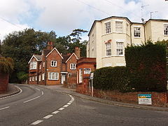
 Berry Hill, part of the developed traditional core | |
Location within Buckinghamshire | |
| Area | 11.22 km2 (4.33 sq mi) |
| Population | 1,669 (2011 census)[1] |
| • Density | 149/km2 (390/sq mi) |
| OS grid reference | SU9182 |
| Civil parish |
|
| Unitary authority | |
| Ceremonial county | |
| Region | |
| Country | England |
| Sovereign state | United Kingdom |
| Post town | MAIDENHEAD |
| Postcode district | SL6 |
| Dialling code | 01628 |
| Police | Thames Valley |
| Fire | Buckinghamshire |
| Ambulance | South Central |
| UK Parliament | |
Taplow is a village and civil parish in the Unitary Authority of Buckinghamshire, England. It sits on the left bank of the River Thames, facing Maidenhead in the neighbouring county of Berkshire, with Cippenham and Burnham to the east. It is the south-westernmost settlement in Buckinghamshire.
The village features a Grade II listed mock-medieval church, the parish church of St Nicholas,[2] as well as a school of the same name. Taplow railway station, on the Great Western Main Line and Elizabeth Line, serves the village, with services to London Paddington, Heathrow, through Central London, Reading and Oxford. There are two conservation areas in the parish, the Taplow Village Conservation Area[3] and the Taplow Riverside Conservation Area.[4] Footpaths connect all parts of the parish to Maidenhead Bridge and to Burnham Beeches, a modest, hilly wood marking the start of the Chiltern Hills.
- ^ "Key Statistics: Dwellings; Quick Statistics: Population Density; Physical Environment: Land Use Survey 2005". Archived from the original on 11 February 2003. Retrieved 22 April 2008.
- ^ Historic England. "Church of St Nicholas (1309135)". National Heritage List for England. Retrieved 25 January 2015.
- ^ "Taplow Village Conservation Area" (PDF). South Bucks District Council. June 2008. Archived (PDF) from the original on 4 March 2016. Retrieved 4 November 2015.
- ^ "Taplow Riverside Conservation Area" (PDF). South Bucks District Council. October 2007. Archived (PDF) from the original on 4 March 2016. Retrieved 4 November 2015.
