| Tararua Range | |
|---|---|
 Tararua Range from Wairarapa | |
| Highest point | |
| Peak | Pukeamoamo / Mitre |
| Elevation | 1,570 m (5,150 ft) |
| Geography | |
| Country | New Zealand |
| Region | Wellington |
| Range coordinates | 40°48′S 175°24′E / 40.8°S 175.4°E |
| Borders on | |


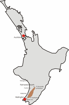
The Tararua Range, often referred to as the Tararua Ranges or Tararua, is one of several mountain ranges in the North Island of New Zealand.
The Tararua Range runs northeast–southwest for 80 km (50 mi) from near Palmerston North to the upper reaches of the Hutt Valley, where the northern tip of the Remutaka Range begins. It is separated in the north from the southern end of the Ruahine Range by the Manawatū Gorge.[1] Most of the Range is wilderness, protected as the Tararua Forest Park.
The highest peak in the Tararua Range is Pukeamoamo / Mitre (not to be confused with Mitre Peak) at 1,570 m (5,150 ft). Other prominent peaks include Mount Bannister at 1,537 m (5,043 ft) and Mount Hector at 1,529 m (5,016 ft), which is named after the scientist Sir James Hector. Its Māori name is Pukemoumou, or 'hill of desolation'.[1]
- ^ a b Maclean, Chris (3 March 2011). "Wellington places – Tararua Range". Te Ara – the Encyclopedia of New Zealand. Retrieved 16 July 2012.
