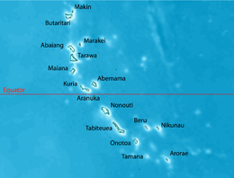
 Map of South Tarawa and North Tarawa within Tarawa Atoll | |
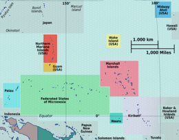
 Map of the Gilbert Islands | |
| Geography | |
|---|---|
| Location | |
| Coordinates | 1°20′N 173°00′E / 1.333°N 173.000°E |
| Archipelago | Gilbert Islands |
| Area | 31.02 km2 (11.98 sq mi) |
| Highest elevation | 3 m (10 ft) |
| Administration | |
Kiribati | |
| Island councils | Betio, North Tarawa, South Tarawa |
| Largest settlement | Betio |
| Demographics | |
| Population | 70,480 (2020) |
| Pop. density | 2,031.5/km2 (5261.6/sq mi) |
| Languages | Gilbertese |
| Ethnic groups | I-Kiribati (95.5%) |
| Additional information | |
| Time zone | |
Tarawa is an atoll and the capital of the Republic of Kiribati,[1][2][3] in the Micronesia region of the central Pacific Ocean. It comprises North Tarawa, which has 6,629 inhabitants and much in common with other more remote islands of the Gilbert group, and South Tarawa, which has 56,388 inhabitants as of 2015[update], half of the country's total population.[4][5] The atoll was the site of the Battle of Tarawa during World War II.
- ^ "Kiribati government website". Government of Kiribati. Archived from the original on 26 June 2010. Retrieved 29 May 2014.
- ^ Kiribati. The World Factbook. Central Intelligence Agency.
- ^ "European Union – list of countries in the world".
- ^ Country files at earth-info.nga.mil Archived 12 August 2005 at the Wayback Machine
- ^ "Kiribati Census Report 2015 Volume 1" (PDF). National Statistics Office, Ministry of Finance and Economic Development, Government of Kiribati. Archived from the original (PDF) on 30 September 2013. Retrieved 17 March 2013.


