| Tarcutta New South Wales | |||||||||||||||
|---|---|---|---|---|---|---|---|---|---|---|---|---|---|---|---|
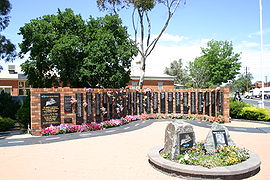
 National Truck Driver Memorial at Tarcutta | |||||||||||||||
 | |||||||||||||||
| Coordinates | 35°16′37″S 147°44′13″E / 35.277056°S 147.736832°E | ||||||||||||||
| Population | 446 (2016 census)[1] | ||||||||||||||
| Postcode(s) | 2652 | ||||||||||||||
| Elevation | 233 m (764 ft) | ||||||||||||||
| • Summer (DST) | AEDT (UTC+11) | ||||||||||||||
| Location |
| ||||||||||||||
| LGA(s) | City of Wagga Wagga | ||||||||||||||
| County | Wynyard | ||||||||||||||
| State electorate(s) | Wagga Wagga | ||||||||||||||
| Federal division(s) | Riverina | ||||||||||||||
| |||||||||||||||
| |||||||||||||||
Tarcutta is a town in south-western New South Wales, Australia. The town is 438 kilometres (272 mi) south-west of Sydney, 3 kilometres (2 mi) east of the Hume Highway, It was proclaimed as a village on 28 October 1890. As of 2016, the town had a population of 446.[1]
It serves a local farming community relying for its prosperity mainly on sheep and cattle, and the interstate truckies who use the town as a halfway change-over point in the trade between the state capital cities of Sydney and Melbourne.[2]
- ^ a b Australian Bureau of Statistics (27 June 2017). "Tarcutta (State Suburb)". 2016 Census QuickStats. Retrieved 27 June 2017.
- ^ "The Real Thing: #6: Halfway and home". Apple Podcasts. 11 October 2016. Retrieved 18 March 2020.
