Tarnobrzeg | |
|---|---|
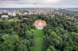
 Skyline with Dzików Castle, city center, river Vistula and Reservoir Machów created in a former sulfur mine | |
| Coordinates: 50°35′N 21°41′E / 50.583°N 21.683°E | |
| Country | |
| Voivodeship | |
| County | city county |
| City rights | 1593 |
| Government | |
| • President | Łukasz Nowak |
| Area | |
| • Total | 85.6 km2 (33.1 sq mi) |
| Elevation | 160 m (520 ft) |
| Population (2017) | |
| • Total | 47,387 |
| • Density | 550/km2 (1,400/sq mi) |
| Time zone | UTC+1 (CET) |
| • Summer (DST) | UTC+2 (CEST) |
| Postal code | 39-400 |
| Area code | +48 015 |
| Car plates | RT |
| Website | http://www.tarnobrzeg.pl/ |
 | |
Tarnobrzeg [tarˈnɔbʐɛk] is a city in south-eastern Poland (historic Lesser Poland), on the east bank of the river Vistula, with 49,419 inhabitants, as of 31 December 2009.[1] Situated in the Subcarpathian Voivodeship (Polish: Województwo podkarpackie) since 1999, it had previously been the capital of Tarnobrzeg Voivodeship (1975–1998). Tarnobrzeg lies in the Sandomierz Basin, and directly borders the town of Sandomierz, Świętokrzyskie Voivodeship. Its history dates back to the year 1593, when it was granted Magdeburg rights, and belonged to the Tarnowski family. For centuries Tarnobrzeg remained a small town, which did not develop until the post-World War II period, when it became center of an industrial area, based on rich sulfur deposits.
- ^ "Population. Size and structure by territorial division 1995-2009". Central Statistical Office 00-925 Warsaw, Al. Niepodległości 208. 2009-12-31. Archived from the original on 2011-11-05. Retrieved 2010-11-04.


