| Tarro Newcastle, New South Wales | |||||||||||||||
|---|---|---|---|---|---|---|---|---|---|---|---|---|---|---|---|
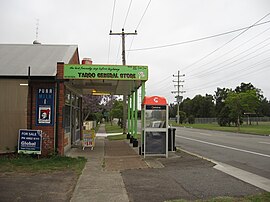
 Tarro General store reopened 2010 | |||||||||||||||
| Coordinates | 32°48′32″S 151°39′22″E / 32.80889°S 151.65611°E | ||||||||||||||
| Population | 1,645 (2016 census)[1] | ||||||||||||||
| • Density | 1,948/km2 (5,050/sq mi) Note1 | ||||||||||||||
| Postcode(s) | 2322 | ||||||||||||||
| Elevation | 10 m (33 ft) | ||||||||||||||
| Area | 6 km2 (2.3 sq mi)Note2 | ||||||||||||||
| Time zone | AEST (UTC+10) | ||||||||||||||
| • Summer (DST) | AEDT (UTC+11) | ||||||||||||||
| Location |
| ||||||||||||||
| LGA(s) | |||||||||||||||
| Region | Hunter[2] | ||||||||||||||
| County | Northumberland[3] | ||||||||||||||
| Parish | Alnwick[3] | ||||||||||||||
| State electorate(s) | Wallsend[4] | ||||||||||||||
| Federal division(s) | Paterson | ||||||||||||||
| |||||||||||||||
Tarro (/tæroʊ/) is a north-western suburb of the Newcastle City Council local government area in the Hunter Region of New South Wales, Australia.[2][3] It, and parts of nearby Beresfield, was originally known as Upper Hexham, "lower" Hexham being an older settlement located about 5 kilometres (3 mi) to the east on the Hunter River. The name "Tarro" reportedly means "stone" in an Aboriginal language.[5]
At the 2006 census, Tarro had a population of 1,558, almost all of which is concentrated in the south-western corner of the suburb.[6][7]
- ^ Australian Bureau of Statistics (27 June 2017). "Tarro (State Suburb)". 2016 Census QuickStats. Retrieved 6 July 2017.
- ^ a b c "Suburb Search - Local Council Boundaries - Hunter (HT) - Newcastle". New South Wales Division of Local Government. Retrieved 18 October 2008.
- ^ a b c "Tarro". Geographical Names Register (GNR) of NSW. Geographical Names Board of New South Wales. Retrieved 18 October 2008.
- ^ "Wallsend". New South Wales Electoral Commission. 28 March 2015. Retrieved 23 November 2019.
- ^ "Place names, origins and meanings". Newcastle City Council. Retrieved 17 October 2008.
- ^ Australian Bureau of Statistics (25 October 2007). "Tarro (State Suburb)". 2006 Census QuickStats. Retrieved 18 October 2008. Map
- ^ "Tarro". Land and Property Management Authority - Spatial Information eXchange. New South Wales Land and Property Information. Retrieved 14 May 2008.
