| Tasang Dam | |
|---|---|
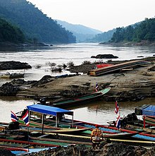
 Salween River downstream of Tasang Dam site | |
| Location | Shan State, Myanmar |
| Coordinates | 20°27′23″N 98°39′0″E / 20.45639°N 98.65000°E |
| Opening date | unknown |
| Construction cost | 6+ billion USD |
| Operator(s) | Myanmar Electric Power Enterprise |
| Dam and spillways | |
| Impounds | Salween River |
| Height | 228 metres (748 ft) |
| Reservoir | |
| Surface area | 870 km2 (340 sq mi) |
| Power Station | |
| Installed capacity | 7110 MW |
| Annual generation | 35,446 GWh per year |
The Tasang Dam (Burmese: တာဆန်းဆည်), also known as the Mong Ton Dam, is a planned multi-purpose dam on the Salween River in the Shan State, Myanmar. The Tasang dam's location will be 480 km (300 mi) northeast of Rangoon and 52.8 km (32.8 mi) west of Mongtong. If completed, Tasang Dam would be the first dam on the Salween River, the largest hydroelectric dam in Myanmar and the tallest dam in Southeast Asia. The Tasang will cost more than US$6 billion and is planned for completion in 2022.[1][2] The groundbreaking ceremony was in March 2007, but construction has been stalled, and there has been little activity at the dam site as of 2008.[1]
Substantial domestic and international controversy surrounds the Tasang Dam project. The Tasang dam is one of five dams the Myanmar Government plans to build on the Salween River.[3]
- ^ a b "Tasang Dam". Burma Rivers Network. 2008. Archived from the original on 19 January 2010. Retrieved 6 February 2010.
- ^ "Myanmar-Thai hydropower project starts on Thanlwin river". Salween Watch. Live Journal. April 5, 2007. Retrieved 8 February 2010.
- ^ "Thailand renews plans to build controversial Myanmar dam". Trend Capital. 2008-03-16. Retrieved 2009-12-24.
