Taschereau | |
|---|---|
 | |
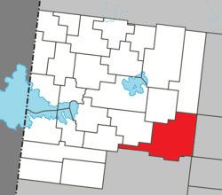
 Location within Abitibi-Ouest RCM | |
| Coordinates: 48°40′N 78°41′W / 48.667°N 78.683°W[1] | |
| Country | Canada |
| Province | Quebec |
| Region | Abitibi-Témiscamingue |
| RCM | Abitibi-Ouest |
| Settled | 1911 |
| Constituted | December 27, 2001 |
| Government | |
| • Mayor | Michael Otis |
| • Federal riding | Abitibi—Témiscamingue |
| • Prov. riding | Abitibi-Ouest |
| Area | |
• Total | 272.50 km2 (105.21 sq mi) |
| • Land | 246.96 km2 (95.35 sq mi) |
| Population (2021)[3] | |
• Total | 898 |
| • Density | 3.6/km2 (9/sq mi) |
| • Pop (2016-21) | |
| • Dwellings | 460 |
| Time zone | UTC−5 (EST) |
| • Summer (DST) | UTC−4 (EDT) |
| Postal code(s) | |
| Area code | 819 |
| Highways | |
| Website | taschereau |
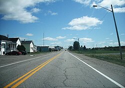
Taschereau is a municipality in northwestern Quebec, Canada in the Abitibi-Ouest Regional County Municipality. It covers 246.97 km2 and had a population of 898 as of the Canada 2021 Census.
The municipality was incorporated on December 27, 2001, when the Village Municipality of Taschereau and the Municipality of Taschereau were amalgamated. It is named after Louis-Alexandre Taschereau.[1]
- ^ a b Cite error: The named reference
toponymiewas invoked but never defined (see the help page). - ^ a b "Taschereau". Répertoire des municipalités (in French). Ministère des Affaires municipales et de l'Habitation. Retrieved 2023-07-12.
- ^ a b "Taschereau census profile". 2021 Census data. Statistics Canada. 9 February 2022. Retrieved 2022-04-19.
