Tasikmalaya | |
|---|---|
| City of Tasikmalaya Kota Tasikmalaya | |
| Other transcription(s) | |
| • Sundanese | Tasikmalaya (Latén) ᮒᮞᮤᮊ᮪ᮙᮜᮚ (Sunda) تاسيكمالايا (Arab Gundul) |
| • Colloquial Sundanese | Tasik (Latén) ᮒᮞᮤᮊ᮪ (Sunda) تاسيق (Arab Gundul) |
Clockwise from the top: Great Mosque of Tasikmalaya, Wiriadinata Airbase, Tasikmalaya Railway Station | |
| Nickname(s): | |
| Motto(s): | |
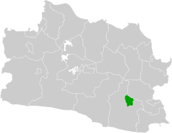
 Location within West Java | |
| Coordinates: 7°18′58″S 108°11′51″E / 7.3161°S 108.1975°E | |
| Country | |
| Region | Java |
| Province | |
| Founded | 2001 |
| Government | |
| • Mayor | Cheka Virgowansyah (Acting) |
| • Vice Mayor | Vacant |
| Area | |
• City | 183.14 km2 (70.71 sq mi) |
| • Metro | 729.4 km2 (281.6 sq mi) |
| Elevation | 340 m (1,120 ft) |
| Population (mid 2023 estimate) | |
• City | 741,760 |
| • Density | 4,100/km2 (10,000/sq mi) |
| • Metro | 1,339,891 |
| • Metro density | 1,800/km2 (4,800/sq mi) |
| [1] | |
| Time zone | UTC+7 (Indonesia Western Time) |
| Area code | (+62) 265 |
| Vehicle registration | Z |
| Website | tasikmalayakota.go.id |
Tasikmalaya is a landlocked city in West Java, Indonesia. The city is sometimes dubbed kota santri (city of religious learners) or "the City of a Thousand Pesantrens" for its abundance of Islamic boarding schools.[2] Located around 120 kilometres (75 mi) southeast from the provincial capital of Bandung, Tasikmalaya is passed by Indonesian National Route 3.
The city is located in the mountainous Priangan region of Java at an elevation of 351 metres (1,151 feet).
The population of the city (excluding the Tasikmalaya Regency, which surrounds the city to the west, south and east) was 634,948 according to the 2010 census,[3] and increased to 716,155 at the 2020 census;[4] the official estimate as at mid 2023 was 741,760 (comprising 375,737 males and 366,023 females).[1] Its built-up (or metro) area (made of Tasikmalaya City and 14 neighbouring districts spread over Tasikmalaya and Ciamis Regencies) was home to 1,214,000 inhabitants as at mid 2023.[5]
- ^ a b Badan Pusat Statistik, Jakarta, 28 February 2024, Kota Tasikmalaya Dalam Angka 2024 (Katalog-BPS 1102001.3278)
- ^ "City of contrasts". 2004. The Straits Times February 27.
- ^ Biro Pusat Statistik, Jakarta, 2011.
- ^ Badan Pusat Statistik, Jakarta, 2021.
- ^ "Tasikmalaya, Indonesia Metro Area Population 1950-2024".


