| Taskan Таскан | |
|---|---|
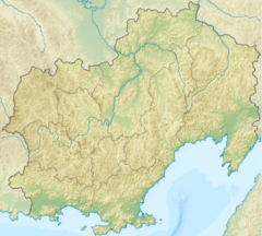
Mouth location in Magadan Oblast, Russia | |
| Location | |
| Federal subject | Magadan Oblast, Russia |
| Physical characteristics | |
| Source | |
| • location | Chersky Range |
| • elevation | 918 m (3,012 ft) |
| Mouth | Kolyma |
• coordinates | 62°40′10″N 150°53′22″E / 62.66944°N 150.88944°E |
• elevation | 301 m (988 ft) |
| Length | 232 km (144 mi) |
| Basin size | 11,200 km2 (4,300 sq mi) |
| Basin features | |
| Progression | Kolyma→ East Siberian Sea |
The Taskan (Russian: Таскан) is a river in the Susuman and Yagodninsky districts of Magadan Oblast, Russia. It is a left hand tributary of the Kolyma. Its length is 232 kilometres (144 mi), with a drainage basin of 11,200 square kilometres (4,300 sq mi).[1] The Taskan was first mapped in the 19th century by explorer Jan Czerski.[2]
Perch, ruffe, gudgeon and burbot are found in the waters of the river.[2]
