| Taum Sauk Mountain | |
|---|---|
 Taum Sauk Mountain is part of a large parks-and-wilderness area. | |
| Highest point | |
| Elevation | 1,772 ft (540 m)[1] |
| Prominence | 512 ft (156 m)[1] |
| Listing | U.S. state high point 41st |
| Coordinates | 37°34′13″N 90°43′40″W / 37.5703266°N 90.7279003°W[2] |
| Geography | |
| Parent range | Saint Francois Mountains |
| Topo map | USGS Ironton |
| Climbing | |
| Easiest route | Hike |
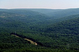
Taum Sauk Mountain /ˈtɔːm ˈsɔːk/[3] in the Saint Francois Mountains is the highest natural point in the U.S. state of Missouri at 1,772 feet (540 m).[4] The topography of Taum Sauk is that of an elongated ridge with a NNW-SSE orientation rather than a peak.[5]
- ^ a b "Taum Sauk Mountain, Missouri". Peakbagger.com. Retrieved 2012-11-09.
- ^ "Taum Sauk Mountain". Geographic Names Information System. United States Geological Survey, United States Department of the Interior. Retrieved 2012-11-09.
- ^ Cite error: The named reference
Bulliswas invoked but never defined (see the help page). - ^ "Elevations and Distances in the United States (online edition)". United States Geological Survey. 2001. Retrieved 2008-01-24.
- ^ Irontown, Missouri, 7.5 Minute Topographic Quadrangle, USGS, 1968 (1978 rev.)
