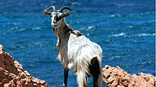


Tavolara is a small island off the northeast coast of Sardinia, Italy. The island is a limestone massif 5 kilometres (3 miles) long and 1 kilometre (0.6 miles) wide, with steep cliffs except at its ends. Its highest point, Monte Cannone, is 565 metres (1,854 feet) above sea level. A cove and beach can be found at each end of the island, Spalmatore di Fuori at the northeast, and Spalmatore di Terra at the southwest. Currently, the island is inhabited by only a handful of families, and has a small cemetery and summer restaurant. The water around the island is a popular spot for scuba diving.

The nearest sizable town is Olbia, and the small fishing village of Porto San Paolo is directly across a small strait. The islands of Molara and Molarotto are nearby.
Most of the population of the island was displaced in 1962 when a NATO radiogoniometric station was constructed on the eastern half of the island. The aerials from the station can be seen from quite a distance, and that entire half of the island is restricted to military personnel.
Tavolara is also home of the VLF-transmitter ICV, which works on 20.27 kHz and 20.76 kHz and which is used for transmitting messages to submarines. It can also be received (but not decoded) by PCs with a coil antenna at the soundcard entrance and FFT-analysis software.
The island and the surrounding waters are part of the Tavolara and Punta Coda Cavallo Marine Preserve created in 1997. The environmental protections placed on the park have added restrictions to the use of the area for tourism.
A natural column of rock on the island's coast resembles a human figure and is known as "the Stone Sentry" or "Pope's Rock."[1] Other stone formations include "Ulysses' Bow" (a natural arch) and the "Grotta del Papa" (a cave accessible by sea and boasting Neolithic cave paintings).
- ^ "Ripley's Believe It or Not," April 25, 1972