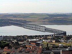
Tay Bridge | |
|---|---|
 Tay Bridge at Dundee, Scotland, from the Dundee Law | |
| Coordinates | 56°26′14.4″N 2°59′18.4″W / 56.437333°N 2.988444°W |
| Carries | Rail traffic |
| Crosses | Firth of Tay |
| Locale | Dundee to Wormit, Scotland |
| Characteristics | |
| Total length | 3,264 metres (10,709 ft) |
| History | |
| Construction start | 22 July 1871 (1st) 6 July 1883 (2nd) |
| Construction end | early 1878 (1st) 1887 (2nd) |
| Opened | 1 June 1878 (1st) 20 June 1887 (2nd) |
| Closed | 28 December 1879 (1st) |
| Location | |
 | |
The Tay Bridge (Scottish Gaelic: Drochaid-rèile na Tatha) carries rail traffic across the Firth of Tay in Scotland between Dundee and the suburb of Wormit in Fife. Its span is 2.75 miles (4.43 kilometres). It is the second bridge to occupy the site.
Plans for a bridge over the Tay to replace the train ferry service emerged in 1854, but the first Tay Bridge did not open until 1878. It was a lightweight lattice design of relatively low cost with a single track. On 28 December 1879, the bridge suddenly collapsed in high winds while a train was crossing, killing everybody on board. The incident is one of the worst bridge-related engineering disasters in history. An enquiry determined that the bridge was insufficiently engineered to cope with high winds.
It was replaced by a second bridge constructed of iron and steel, with a double track, parallel to the remains of the first bridge. Work commenced on 6 July 1883 and the bridge opened in 1887. The new bridge was subject to extensive testing by the Board of Trade, which resulted in a favourable report. In 2003, the bridge was strengthened and refurbished, winning a British Construction Industry Engineering Award to mark the scale and difficulty of the project.